Precision agriculture is a farm management philosophy that uses technology to observe, measure, and respond to variability in crops, soils, livestock, and environmental conditions at a level of detail that was unimaginable in conventional farming. Rather than treating an entire field or herd as a uniform unit, precision agriculture breaks farming down to the smallest practical management zone — sometimes as fine as a square metre — allowing inputs such as water, fertilizer, pesticides, and seed to be applied exactly where they are needed and in exactly the right quantities.
The global precision agriculture market was valued at approximately USD 9.5 billion in 2023 and is projected to exceed USD 25 billion by 2030, growing at a compound annual growth rate of around 13–14%, driven by rising food demand, shrinking arable land, labour shortages, and increasing pressure to reduce agriculture’s environmental footprint.
The economic case for precision agriculture is compelling and well-documented. Studies across multiple cropping systems consistently show that variable-rate application of fertilizers guided by soil testing and remote sensing data can reduce input costs by 10–25% while maintaining or improving yields. GPS-guided machinery reduces overlapping passes, cutting fuel use and field time by 10–15% on large arable operations.
In irrigated systems, soil moisture sensors and evapotranspiration models have been shown to reduce water use by 20–50% compared to calendar-based irrigation scheduling, a critical saving in water-scarce regions. Across the United States alone, it is estimated that widespread adoption of precision agriculture practices could reduce nitrogen fertilizer use by more than 20%, with corresponding reductions in nitrous oxide emissions and nutrient runoff into waterways.
Adoption of precision agriculture has accelerated rapidly in recent years, driven by falling hardware costs, the proliferation of cloud computing, and the emergence of powerful artificial intelligence and machine learning platforms capable of processing the vast data streams generated by modern farm sensors, drones, and satellites. Drone-based crop scouting, once the preserve of well-resourced large farms, has become accessible to smallholders in parts of Asia and Africa through service provider models where farmers pay per hectare for sensing flights.
Satellite imagery with resolutions of 3–5 metres is now freely or cheaply available through platforms such as Sentinel, Planet Labs, and commercial providers, making remote crop monitoring accessible at a fraction of its previous cost. The convergence of these technologies is shifting precision agriculture from a niche adopted by large-scale operations to a mainstream approach applicable across diverse farming systems globally.
Despite its promise, precision agriculture faces real challenges that continue to limit its adoption, particularly among smallholder farmers in developing countries. The initial capital costs of GPS receivers, variable-rate applicators, soil sensors, and farm management software remain significant, and the agronomic knowledge required to interpret data and make sound management decisions is not always available.
Connectivity remains a fundamental constraint — many precision agriculture platforms require reliable internet access for data upload, cloud processing, and decision support, which is unavailable across large portions of rural Africa, South Asia, and Latin America. Interoperability between hardware and software platforms from different manufacturers creates data management headaches for farmers and advisors alike. Addressing these barriers through policy support, affordable financing, and locally adapted technology design will be essential to ensuring that the productivity and sustainability benefits of precision agriculture are distributed equitably.

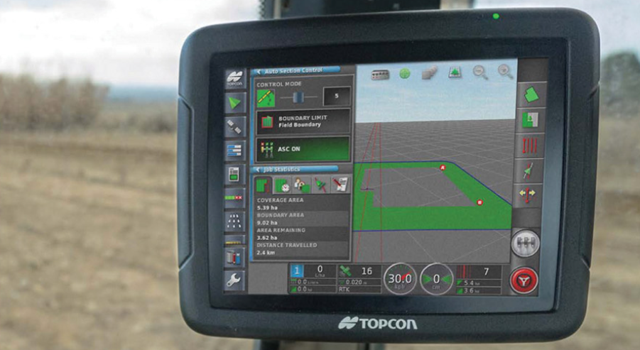
GPS Guidance and Auto-Steer Systems (Global Positioning System)
GPS guidance and auto-steer systems use satellite positioning signals to guide tractors and self-propelled machinery along precisely defined, parallel passes across fields, eliminating the overlapping and skipped strips that occur with manual steering. Modern systems achieve field accuracy of 2–5 cm using RTK (Real-Time Kinematic) correction signals, allowing machinery to follow the same tracks pass after pass and season after season — a practice known as controlled traffic farming that minimizes soil compaction.
Fuel savings of 10–15%, input savings from reduced overlap, and operator fatigue reduction are consistently documented benefits. Auto-steer systems are among the most widely adopted precision agriculture technologies globally, standard equipment on new tractors sold by all major manufacturers and retrofittable to older machines.
Variable Rate Technology (VRT Applicators)
Variable rate technology allows spreaders, sprayers, seeders, and other applicators to automatically adjust their application rate as they move across a field, delivering more or less of a given input in response to pre-loaded prescription maps generated from soil tests, yield maps, or remote sensing data. A fertilizer spreader equipped with VRT, for example, might apply 120 kg/ha of nitrogen in a high-yield-potential zone and only 60 kg/ha in a sandy, low-productivity area of the same field — optimizing return on investment and reducing environmental risk from over-application.
VRT systems require integration with GPS positioning, field mapping software, and agronomic decision support to function effectively. Studies across grain-growing regions of the USA, Europe, and Australia have documented input savings of 10–20% alongside yield maintenance or improvement when VRT is deployed on variable soils.
Soil Electrical Conductivity Sensors (EC Mapping)
Soil electrical conductivity sensors measure how readily an electrical current passes through the soil, which correlates closely with soil texture, organic matter content, salinity, and water-holding capacity — all key determinants of crop productivity. Towed behind a tractor, EC sensors such as the Veris 3100 or EM38 rapidly map soil variability across entire fields at a resolution and cost unachievable through conventional grid soil sampling.
The resulting EC maps are used to delineate management zones — areas of similar soil behaviour that can be managed with distinct input prescriptions. A single EC mapping pass can identify zones that would require dozens of conventional soil samples to characterize, dramatically reducing sampling costs while providing a spatially continuous picture of soil variability across the field.
Yield Monitors and Yield Mapping (Combine-Mounted Sensors)
Yield monitors fitted to combine harvesters measure grain flow, moisture content, and harvest speed continuously during harvest operations, generating georeferenced yield data that is compiled into detailed yield maps showing crop productivity variation across each field. A typical yield map reveals yield differences of 30–50% or more within a single field — variation invisible to the eye during the growing season but critical for understanding the root causes of underperformance.
Yield maps accumulated over multiple seasons form the foundational dataset of precision agriculture, revealing consistent patterns of high and low productivity that guide soil sampling, input management, drainage investment, and variety selection decisions. Modern yield monitors are standard equipment on most new combine harvesters from major manufacturers.
Unmanned Aerial Vehicles (Agricultural Drones)
Agricultural drones carry multispectral, hyperspectral, thermal, or RGB cameras and fly pre-programmed missions over fields to capture high-resolution imagery for crop scouting, stress detection, stand count assessment, disease monitoring, and biomass estimation. A single drone flight covering 50–100 hectares in 20–30 minutes can generate imagery with resolutions of 3–10 cm per pixel — sufficient to identify individual plants, detect early pest and disease outbreaks, and quantify lodging, waterlogging, or nutrient stress.
Beyond sensing, spray drones equipped with tanks and nozzle booms are increasingly used for targeted pesticide and foliar fertilizer applications, particularly in paddy rice, orchards, and steep terrain inaccessible to ground machinery. The drone services market in agriculture is growing at over 30% annually in Asia, driven particularly by China’s rapid adoption of spray drone technology.
Satellite Remote Sensing (Multispectral Imagery)
Satellite-based remote sensing provides repeated, synoptic views of crop canopies across vast areas, enabling the monitoring of crop growth, stress, and phenology at scales from individual fields to entire regions. Multispectral satellites measure reflectance in visible and near-infrared bands, from which vegetation indices such as NDVI (Normalized Difference Vegetation Index) are calculated to quantify canopy density, chlorophyll content, and crop vigour.
Commercial satellites from providers including Planet Labs, Maxar, and Airbus provide imagery at resolutions of 0.5–5 metres, enabling farm-level crop monitoring globally. Freely available imagery from the European Space Agency’s Sentinel-2 satellites, with a 5-day revisit frequency and 10-metre resolution, has democratized satellite-based crop monitoring and enabled the development of low-cost and free crop advisory platforms for farmers in developing countries.
Soil Moisture Sensors (In-Field Monitoring)
Soil moisture sensors installed at multiple depths in the root zone measure the volumetric water content of the soil continuously and transmit readings wirelessly to farm management platforms, enabling irrigation decisions based on actual plant-available water status rather than calendar scheduling or rough estimates. Technologies include capacitance sensors, tensiometers, time-domain reflectometry (TDR) probes, and neutron moisture meters, each with specific accuracy, cost, and installation characteristics.
Studies in irrigated horticulture, viticulture, and row crops consistently document water savings of 20–50% when irrigation is managed using soil moisture data, alongside improvements in crop quality and reductions in leaching of nutrients below the root zone. IoT-connected sensor networks allow farmers and consultants to monitor soil water status remotely via smartphone or computer in real time.
Weather Stations and Microclimate Monitoring (In-Field Meteorology)
Precision in-field weather stations record temperature, humidity, rainfall, wind speed, solar radiation, and leaf wetness at high temporal resolution directly within or adjacent to cropped fields, providing data far more accurate and locally relevant than readings from distant public meteorological stations. This microclimate data feeds disease risk models — such as those for late blight in potatoes, downy mildew in grapes, and sclerotinia in canola — allowing targeted, timely fungicide applications only when actual risk thresholds are exceeded rather than on calendar schedules.
Networks of low-cost IoT weather stations are now deployed across farm landscapes, providing spatial coverage of microclimate variation that reveals frost pockets, drainage areas, and exposed ridges requiring differentiated crop management. Integration with crop models allows growing degree day accumulation and phenology prediction to support planting, irrigation, and harvest timing.
Geographic Information Systems (Farm GIS Platforms)
Geographic Information Systems compile, display, and analyse spatial data from multiple sources — soil surveys, yield maps, satellite imagery, topography, drainage infrastructure, and field boundaries — within a unified digital map environment that allows farmers and agronomists to identify patterns, make management decisions, and generate input prescription maps. Modern farm GIS platforms such as John Deere Operations Center, Trimble Ag Software, and Climate FieldView are cloud-based, accessible via smartphone and computer, and capable of integrating data from multiple machinery brands and sensor types. GIS analysis of multi-year yield maps overlaid with soil EC data and topography can reveal the root causes of yield variability far more reliably than any single data layer alone, enabling targeted investment in drainage, lime application, compaction remediation, or variety changes in underperforming zones.
NDVI Sensors and Canopy Reflectance Meters (Proximal Sensing)
Ground-based NDVI (Normalized Difference Vegetation Index) sensors and canopy reflectance meters are mounted on sprayer or fertilizer applicator booms and measure crop canopy reflectance in real time as the machine moves across the field, instantly calculating a measure of canopy greenness and biomass that is used to adjust nitrogen application rate on the go. The GreenSeeker and N-Sensor are well-known examples of this technology used extensively in grain crops.
Studies in winter wheat in Europe and North America have documented nitrogen savings of 15–25% and equivalent or improved yields when real-time canopy sensing drives variable nitrogen top-dressing compared to uniform application. Unlike satellite or drone imagery that must be processed before use, proximal canopy sensors provide instantaneous, actionable data for variable-rate application within the same field operation.
Precision Irrigation Systems (Variable Rate Irrigation)
Precision irrigation systems, including variable rate centre pivots, drip irrigation with zone controls, and sensor-triggered irrigation controllers, deliver water with spatial and temporal precision that conventional irrigation systems cannot achieve. Variable rate centre pivots equipped with GPS and individually controlled nozzle sections can vary application depth across different management zones within a single revolution, applying more water to sandy, low-water-holding-capacity soils and less to heavier soils — or bypassing non-crop areas such as roads, waterways, and buildings entirely.
Drip irrigation systems guided by soil moisture sensors and crop evapotranspiration models achieve water use efficiencies of 85–95%, compared to 50–70% for sprinkler systems and 35–45% for surface flood irrigation. The economic and environmental case for precision irrigation is strongest in water-scarce regions facing increasing competition for freshwater resources.
Crop Scouting Apps and Digital Pest Identification (Mobile Advisory Tools)
Smartphone-based crop scouting applications allow farmers and agronomists to record pest, disease, and weed observations in the field with GPS-tagged photographs, severity ratings, and growth stage data, building a georeferenced database of field health that can be reviewed, shared, and used to generate spray recommendations and track intervention outcomes over time.
AI-powered image recognition features embedded in platforms such as Plantix, Agrio, and Farmsense can identify hundreds of crop diseases, nutrient deficiencies, and pest species from photographs taken with a standard smartphone camera, placing near-instant diagnostic support in the hands of farmers in locations without ready access to trained agronomists. Studies in sub-Saharan Africa and South Asia have documented significant reductions in pesticide misuse when AI-based diagnostic tools are accessible to smallholder farmers who previously made spray decisions based on guesswork.
Precision Seeding Technology (Variable Rate Planters)
Precision planters equipped with individual row shut-off, variable seed spacing, and variable seeding rate capability allow farmers to adjust plant populations across a field in response to soil productivity zones, water availability, and historical yield data. High-productivity zones with good water retention may receive higher seed rates to maximize yield potential, while drought-prone sandy areas are seeded at lower populations that can be sustained through dry periods without yield-limiting competition. Individual row clutches eliminate double-seeding at headlands and point rows, saving seed costs in every field operation.
Studies in maize production in the US Corn Belt have documented seed savings of 5–10% from double-seeding elimination alone, while population optimization across yield zones provides additional economic returns in variable fields.
Precision Spraying Technology (Spot Spraying and Boom Section Control)
Precision spraying encompasses boom section control — which automatically switches sprayer boom sections off when crossing previously sprayed areas or field boundaries — and spot or patch spraying, where individual nozzles or small boom sections are switched on only when a sensor detects a weed, pest, or disease target directly below them. Boom section control alone reduces pesticide overlap by 5–15% on irregular-shaped fields, while spot spraying with optical or AI-based weed detection can reduce herbicide use by 50–90% in certain cropping situations, with corresponding cost savings and reductions in herbicide resistance selection pressure.
Companies including John Deere (See & Spray), Bilberry, and Bosch Digital Farming have commercialized AI-driven camera systems capable of distinguishing crop plants from weeds at field-operation speeds, representing one of the most transformative developments in precision agriculture crop protection.
Livestock Precision Management (Electronic Ear Tags and Wearables)
Precision livestock farming applies sensor technology to individual animals, monitoring behaviour, location, rumination, activity, body temperature, and reproductive status continuously and automatically. Electronic ear tags and collar-mounted sensors transmit real-time data to farm management software that alerts farmers to oestrus events for optimized breeding timing, early signs of illness detectable as reduced rumination or activity, calving events, and grazing behaviour patterns that indicate pasture quality or animal welfare concerns.
Studies have shown that automated oestrus detection using activity monitors achieves conception rates 10–15% higher than visual detection alone. GPS-tracked livestock collars enable virtual fencing systems where animals are guided by audio and vibration cues rather than physical fences, reducing fencing infrastructure costs and enabling flexible, responsive grazing management.
Tissue Testing and Rapid Nutrient Analysis (Plant Sap Analysis)
Tissue testing and plant sap analysis provide direct measurements of the nutrient concentrations within crop plant leaves and stems during the growing season, offering a real-time picture of plant nutrient status that complements soil testing — which measures what nutrients are available in the soil rather than what the plant is actually taking up.
Rapid sap analysis platforms can measure nitrate, potassium, calcium, magnesium, and other nutrients in field-pressed leaf sap within minutes using portable meters and test strips, enabling same-day corrective fertilizer applications when deficiencies are detected. This approach is particularly valuable in high-value horticultural crops such as tomatoes, peppers, lettuce, and strawberries where rapid growth and high productivity create intense, dynamic nutrient demands that static soil tests cannot capture adequately.
Precision Soil Sampling (Grid and Zone-Based Sampling)
Precision soil sampling moves beyond the single composite soil sample traditionally taken from an entire field to collect dozens or hundreds of individual georeferenced samples at regular grid intervals or from within delineated management zones, building a detailed spatial picture of soil nutrient levels, pH, organic matter, and other properties across each field.
Sampling densities of one sample per 0.4–2 hectares are typical in precision agriculture systems, compared to one composite sample per 10–50 hectares in conventional practice. The resulting soil nutrient maps drive variable-rate applications of lime, phosphorus, potassium, and micronutrients that correct deficiencies precisely where they occur and avoid wasteful applications in already-adequate areas. Conducted every 3–5 years, precision soil sampling forms the backbone of site-specific nutrient management planning.
Farm Management Information Systems (FMIS Platforms)
Farm Management Information Systems are integrated software platforms that aggregate data from all aspects of farm operations — field records, soil tests, inputs purchased and applied, crop observations, weather, machinery maintenance, financial accounts, and harvest results — into a single digital environment that supports planning, record-keeping, regulatory compliance, and analysis.
Platforms such as Agworld, Granular, Agrivi, and FarmLogs are used by farmers and agronomists to plan crop rotations, generate spray records, track input costs against yield outcomes, and benchmark farm performance over time. Integration with precision hardware — GPS receivers, yield monitors, variable rate controllers — allows automatic population of field records from machinery data without manual data entry. As regulatory requirements for farm record-keeping intensify — particularly around pesticide use, carbon accounting, and sustainability certification — robust FMIS platforms are becoming an operational necessity for commercial farms.
Hyperspectral and Thermal Imaging (Advanced Aerial Sensing)
Hyperspectral cameras capture reflectance data across hundreds of narrow spectral bands — far beyond the three to ten bands captured by standard multispectral cameras — enabling the detection of crop stress, disease, and nutritional conditions with a precision and early-warning capability that multispectral imagery cannot match.
Thermal cameras detect surface temperature variation in crop canopies, which reflects transpiration rates and therefore water stress — stressed, poorly transpiring plants are warmer than well-watered neighbours, making thermal imagery a powerful tool for identifying irrigation deficits and root zone problems at early stages. Both technologies are most commonly deployed on drones or manned aircraft due to the size and cost of sensors, though miniaturization is rapidly making them accessible for routine farm use. Research applications of hyperspectral imaging have demonstrated the ability to detect Fusarium infection in wheat heads and citrus greening disease before visual symptoms become apparent.
Robotic and Autonomous Farm Vehicles (Agricultural Robots)
Agricultural robots and autonomous vehicles are emerging from research and early commercial deployments to begin reshaping field operations in horticulture, arable farming, and viticulture. Small, lightweight autonomous robots such as the Fendt Xaver seeding robot and the Small Robot Company’s Tom weeding robot operate in swarms, performing field operations with minimal soil compaction and very precise, plant-level intervention.
Robotic harvesters for strawberries, apples, asparagus, and lettuce are in commercial deployment in Europe, North America, Japan, and Australia, addressing critical labour shortages in horticultural industries. Autonomous tractors from manufacturers including John Deere, CNH Industrial, and Kubota are beginning commercial rollout, enabling round-the-clock field operations without operator fatigue constraints. The agricultural robotics market is projected to grow from approximately USD 7 billion in 2023 to over USD 20 billion by 2030.
Artificial Intelligence and Machine Learning Platforms (Crop Decision Systems)
AI and machine learning platforms process the enormous datasets generated by sensors, satellites, drones, and farm machinery to identify patterns, predict outcomes, and generate management recommendations that would be impossible for humans to derive manually from raw data. Applications include yield prediction models that estimate final crop yield weeks before harvest from satellite imagery and weather data, disease risk forecasting systems that predict outbreak probability from weather and crop development data, and optimized planting date and variety selection algorithms trained on decades of historical trial data and farm records.
Companies including The Climate Corporation, Taranis, aWhere, and Cropio have built large-scale AI platforms serving millions of hectares globally. The predictive power of these platforms improves with each additional season of data, creating a compounding advantage for farms and regions that have invested in data capture over time.
Blockchain and Traceability Platforms (Supply Chain Transparency)
Blockchain and digital traceability platforms create immutable, transparent records of agricultural production — linking farm-level data on inputs, practices, soil health, water use, and certifications to supply chain movements, processing, and retail — enabling verifiable claims about food origin, sustainability practices, and quality that consumers and buyers increasingly demand. In precision agriculture, integration of field-level data with blockchain traceability allows premiums for sustainably produced, responsibly managed crops to flow back to farmers who can demonstrate compliance through their digital farm records.
Platforms such as IBM Food Trust, AgriDigital, and Farmers Business Network are active in this space. Regulatory frameworks in the European Union and the United States are increasingly mandating traceability for food safety and environmental compliance, making digital record systems a growing operational requirement for farms supplying premium markets.
Telematics and Machinery Management (Fleet Monitoring)
Agricultural telematics systems monitor the location, operating status, fuel consumption, engine hours, fault codes, and field performance of farm machinery fleets in real time via GPS and cellular connectivity, enabling proactive maintenance scheduling, optimized machinery deployment, and detailed cost-per-hectare analysis across farm operations.
John Deere’s Operations Center, CNH’s AFS Connect, and AGCO’s Fuse Technologies are leading manufacturer-specific examples, while third-party platforms provide brand-agnostic fleet management. Telematics data reveals inefficiencies in machinery use — idle time, excessive transport between fields, suboptimal machine settings — that can be corrected to reduce fuel costs and machinery wear. Predictive maintenance alerts generated from engine and drivetrain telemetry allow service interventions before breakdowns occur, reducing costly downtime during critical planting and harvest windows.
Nutrient Management Software (Fertilizer Decision Support)
Nutrient management software integrates soil test results, crop yield goals, removal coefficients, organic matter dynamics, and local fertilizer price data to generate optimized, economically rational, environmentally responsible fertilizer plans for each field and each crop in a rotation. Platforms such as Encirca Nutrients, SST Summit, and Adapt-N incorporate weather-driven nitrogen cycling models that account for in-season nitrogen mineralization, leaching risk, and denitrification to refine in-season nitrogen recommendations beyond what static soil tests alone can deliver.
Regulatory requirements for nutrient management plans — already mandatory for farms above certain size thresholds in many European countries and US states — are extending to wider farm populations, making software-assisted planning increasingly necessary. Studies consistently show that software-optimized nutrient plans reduce nitrogen application by 10–20% without compromising yield.
Precision Livestock Feeding Systems (Automated Feed Management)
Precision livestock feeding systems use individual animal identification — via RFID ear tags or transponders — combined with automated feed dispensers and feed management software to allocate specific rations to individual animals based on their lactation stage, body condition, production level, and nutritional requirements, rather than providing a uniform diet to the entire group.
In dairy systems, precision feeding has been shown to reduce total feed costs by 5–15% while improving milk production and reproductive performance by ensuring that high-producing animals receive adequate nutrition and lower-producing animals are not overfed at the expense of feed efficiency. Robotic milking systems integrate seamlessly with precision feeding platforms, using milking visit data to update individual ration allocations in real time. The technology is most mature in the dairy sector but is advancing rapidly in pig, poultry, and beef feedlot systems.
Crop Simulation and Decision Support Models (Crop Modelling Software)
Crop simulation models such as APSIM, DSSAT, and AquaCrop use mathematical representations of plant growth, soil water dynamics, nutrient cycling, and weather interactions to simulate crop development and yield under different management scenarios, allowing farmers and advisors to evaluate the likely outcomes of different planting dates, varieties, irrigation strategies, and fertilizer programs before committing inputs in the field.
These tools are used at farm level for tactical decision support — when to plant, how much nitrogen to apply, whether to irrigate — as well as at regional and national levels for food security assessment and climate adaptation planning. Integration of crop models with real-time weather data and satellite-derived crop status information is advancing rapidly, enabling dynamic in-season yield forecasting and management adjustment that static pre-season planning cannot achieve.
Carbon and Sustainability Measurement Platforms (Agri-Environmental Accounting)
Carbon and sustainability measurement platforms quantify the greenhouse gas emissions, soil carbon sequestration, water use, biodiversity impacts, and other environmental outcomes associated with farm management decisions, enabling farmers to demonstrate environmental performance, access carbon markets, and comply with sustainability reporting requirements from food companies and governments.
Platforms such as Cool Farm Tool, Agreena, Indigo Ag, and Regrow Ag combine farm practice data — tillage, cover cropping, fertilizer use, livestock management — with soil and climate models to estimate emissions and carbon stocks at field level. As voluntary and regulatory carbon markets for agriculture develop globally, these platforms provide the measurement, reporting, and verification (MRV) infrastructure necessary to generate tradeable carbon credits from farm-level practice changes such as reduced tillage, improved fertilizer efficiency, and grassland restoration.